

Current watches, warnings, and advisories for Missouri
Flood Warning issued April 6 at 8:42AM CDT until April 9 at 10:41PM CDT by NWS Paducah KY
...The Flood Warning is extended for the following rivers in Missouri... Current River near Doniphan affecting Ripley County. .Heavy rainfall of 5 to 8 inches that occurred across the basin area has resulted in river levels rising to major levels on the Current River at Doniphan. * WHAT...Major flooding is occurring and major flooding is forecast. * WHERE...Current River near Doniphan. * WHEN...Until late Wednesday evening. * ADDITIONAL DETAILS... - At 7:30 AM CDT Sunday the stage was 22.7 feet. - Recent Activity...The maximum river stage in the 24 hours ending at 7:30 AM CDT Sunday was 22.8 feet. - Forecast...The river is expected to rise to a crest of 23.5 feet this evening. It will then fall below flood stage Wednesday afternoon. - Flood stage is 13.0 feet. - Flood History...This crest compares to a previous crest of 23.8 feet on 4/26/2011. - http://www.weather.gov/safety/flood
Flood Warning issued April 6 at 8:38AM CDT until April 6 at 7:00PM CDT by NWS Paducah KY
* WHAT...Flooding caused by excessive rainfall continues. * WHERE...Portions of western Kentucky, including the following county, Ballard and southeast Missouri, including the following counties, Mississippi and New Madrid. * WHEN...Until 700 PM CDT Sunday. * IMPACTS...Flooding of rivers, creeks, streams, and other low-lying and flood-prone locations is imminent or occurring. Low-water crossings are inundated with water and may not be passable. * ADDITIONAL DETAILS... - At 836 AM CDT, Even though the heavy rain has ended, flooding continues across the warned area. Between 6 and 9 inches of rain have fallen since the start of the event on Wednesday. - Additional light rainfall amounts up to one tenth of an inch are possible in the warned area. Flooding impacts will continue. - Some locations that will experience flooding include... Sikeston, Charleston, Portageville, East Prairie, New Madrid, Cairo, Lilbourn, La Center, Miner, Wickliffe, Big Oak Tree State Park, Hunter-Dawson State Historic Site, Towosahgy State Historic Site, Malden, Gideon, Morehouse, Bertrand, Parma, Barlow and Matthews. - http://www.weather.gov/safety/flood
Flood Warning issued April 6 at 8:36AM CDT until April 6 at 7:00PM CDT by NWS Paducah KY
* WHAT...Flooding caused by excessive rainfall continues. * WHERE...A portion of southeast Missouri, including the following counties, Cape Girardeau, New Madrid, Scott and Stoddard. * WHEN...Until 700 PM CDT Sunday. * IMPACTS...Flooding of rivers, creeks, streams, and other low-lying and flood-prone locations is imminent or occurring. * ADDITIONAL DETAILS... - At 832 AM CDT, Even though heavy rain has ended, substantial flooding continues across much of the warned area. Between 7 and 11 inches of rain have fallen since the start of the event on Wednesday. Additional light rainfall amounts up to one tenth of an inch are possible in the warned. - Flooding impacts will continue. - Some locations that will experience flooding include... Cape Girardeau, Sikeston, Jackson, Dexter, Scott City, Portageville, New Madrid, Chaffee, Bernie, Bloomfield, Advance, Oran, Lilbourn, Miner, Benton, Hunter-Dawson State Historic Site, Bollinger Mill State Historic Site, Trail Of Tears State Park, Malden and Gideon. - http://www.weather.gov/safety/flood
Flood Warning issued April 6 at 8:31AM CDT until April 6 at 7:00PM CDT by NWS Paducah KY
* WHAT...Flooding caused by excessive rainfall continues. * WHERE...A portion of southeast Missouri, including the following counties, Bollinger, Perry and Wayne. * WHEN...Until 700 PM CDT Sunday. * IMPACTS...Flooding of rivers, creeks, streams, and other low-lying and flood-prone locations is imminent or occurring. Low-water crossings are inundated with water and may not be passable. * ADDITIONAL DETAILS... - At 824 AM CDT, Even though the heavy rain has ended, substantial flooding continues across much of the warned area. Between 6 and 8 inches of rain have fallen since the start of the event on Wednesday. Additional light rainfall amounts up to one tenth of an inch are possible in the warned area. - Flooding impacts will continue. - Some locations that will experience flooding include... Perryville, Piedmont, Marble Hill, Greenville, Sam A. Baker State Park, Lake Wappapello State Park, Grand Tower, Altenburg, Williamsville, Grassy, Cascade, Patton, Leopold, Alliance, Lodi, Shook, Wappapello, Frohna, Mill Spring and Sedgewickville. - http://www.weather.gov/safety/flood
Flood Warning issued April 6 at 8:28AM CDT until April 6 at 7:15PM CDT by NWS Springfield MO
...The Flood Warning continues for the following rivers in Missouri... Roubidoux Creek Near Waynesville affecting Pulaski County. ...The Flood Warning is extended for the following rivers in Missouri... Big Piney below Fort Leonard Wood -East Gate affecting Pulaski County. Gasconade River at Jerome affecting Phelps County. For the Roubidoux Creek...including Waynesville...Minor flooding is forecast. For the Big Piney River...including Fort Leonard Wood - East Gate... Moderate flooding is forecast. For the Gasconade River...including Jerome...Minor flooding is forecast. * WHAT...Minor flooding is occurring and minor flooding is forecast. * WHERE...Roubidoux Creek near Waynesville. * WHEN...Until this evening. * IMPACTS...At 9.0 feet, the RV Park on the west side of Roubidoux in Waynesville just north of the Business 66 bridge floods. Spring Road near I-44 floods. * ADDITIONAL DETAILS... - At 7:30 AM CDT Sunday the stage was 10.8 feet. - Bankfull stage is 7.0 feet. - Recent Activity...The maximum river stage in the 24 hours ending at 7:30 AM CDT Sunday was 10.9 feet. - Forecast...The river is expected to fall below flood stage this afternoon and continue falling to 2.4 feet Friday morning. - Flood stage is 7.0 feet. - Flood History...This crest compares to a previous crest of 10.8 feet on 05/06/2022. - http://www.weather.gov/safety/flood
Flood Warning issued April 6 at 8:28AM CDT until April 7 at 6:33PM CDT by NWS Springfield MO
...The Flood Warning continues for the following rivers in Missouri... Roubidoux Creek Near Waynesville affecting Pulaski County. ...The Flood Warning is extended for the following rivers in Missouri... Big Piney below Fort Leonard Wood -East Gate affecting Pulaski County. Gasconade River at Jerome affecting Phelps County. For the Roubidoux Creek...including Waynesville...Minor flooding is forecast. For the Big Piney River...including Fort Leonard Wood - East Gate... Moderate flooding is forecast. For the Gasconade River...including Jerome...Minor flooding is forecast. * WHAT...Minor flooding is occurring and moderate flooding is forecast. * WHERE...Big Piney below Fort Leonard Wood - East Gate. * WHEN...Until tomorrow evening. * IMPACTS...At 15.0 feet, moderate flood stage. Water at the lower TA 250 Training Ground is three feet deep. * ADDITIONAL DETAILS... - At 7:00 AM CDT Sunday the stage was 13.4 feet. - Bankfull stage is 8.0 feet. - Recent Activity...The maximum river stage in the 24 hours ending at 7:00 AM CDT Sunday was 13.4 feet. - Forecast...The river is expected to rise to a crest of 15.0 feet this afternoon. It will then fall below flood stage early tomorrow afternoon. - Flood stage is 8.0 feet. - Flood History...This crest compares to a previous crest of 15.1 feet on 06/19/1948. - http://www.weather.gov/safety/flood
Flood Warning issued April 6 at 8:28AM CDT until April 8 at 10:36AM CDT by NWS Springfield MO
...The Flood Warning continues for the following rivers in Missouri... Roubidoux Creek Near Waynesville affecting Pulaski County. ...The Flood Warning is extended for the following rivers in Missouri... Big Piney below Fort Leonard Wood -East Gate affecting Pulaski County. Gasconade River at Jerome affecting Phelps County. For the Roubidoux Creek...including Waynesville...Minor flooding is forecast. For the Big Piney River...including Fort Leonard Wood - East Gate... Moderate flooding is forecast. For the Gasconade River...including Jerome...Minor flooding is forecast. * WHAT...Minor flooding is forecast. * WHERE...Gasconade River at Jerome. * WHEN...Until late Tuesday morning. * IMPACTS...At 18.5 feet, flood waters affect low lying residential areas. * ADDITIONAL DETAILS... - At 7:45 AM CDT Sunday the stage was 14.8 feet. - Bankfull stage is 15.0 feet. - Forecast...The river is expected to rise above flood stage this morning to a crest of 17.8 feet just after midnight tonight. It will then fall below flood stage late tomorrow evening. - Flood stage is 15.0 feet. - Flood History...This crest compares to a previous crest of 17.9 feet on 03/21/1998. - http://www.weather.gov/safety/flood
Flood Warning issued April 6 at 8:22AM CDT until April 6 at 7:00PM CDT by NWS Paducah KY
* WHAT...Flooding caused by excessive rainfall continues. * WHERE...A portion of southeast Missouri, including the following county, Carter. * WHEN...Until 700 PM CDT Sunday. * IMPACTS...Flooding of rivers, creeks, streams, and other low-lying and flood-prone locations is imminent or occurring. * ADDITIONAL DETAILS... - At 820 AM CDT, Even though the heavy rain has ended, substantial flooding continues across much of the warned area.Between 4 and 7 inches of rain have fallen since the start of the event on Wednesday. Additional light rainfall amounts of up to one tenth of an inch are possible in the warned area. - Flooding impacts will continue. - Some locations that will experience flooding include... Van Buren, Ellsinore, Hunter, Fremont and Grandin. - http://www.weather.gov/safety/flood
Flood Warning issued April 6 at 8:11AM CDT until April 6 at 7:00PM CDT by NWS Paducah KY
* WHAT...Flooding caused by excessive rainfall is expected. * WHERE...A portion of southeast Missouri, including the following counties, Butler and Ripley. * WHEN...Until 700 PM CDT Sunday. * IMPACTS...Flooding of rivers, creeks, streams, and other low-lying and flood-prone locations is imminent or occurring. * ADDITIONAL DETAILS... - At 808 AM CDT, Even though the heavy rain has ended, substantial flooding continues across much of the warned area. Between 5 and 9 inches of rain have fallen since the start of the event on Wednesday. Additional light rainfall amounts up to one tenth of an inch are possible in the warned area. - Flooding impacts will continue. - Some locations that will experience flooding include... Poplar Bluff, Doniphan, Naylor, Neelyville, Qulin, Fisk, Fairdealing, Milltown, Oxly, Budapest, Harviell, Brush Arbor, Hendrickson, Gatewood, Handy, Briar and Rombauer. - http://www.weather.gov/safety/flood
Flood Warning issued April 6 at 8:09AM CDT until April 6 at 6:00PM CDT by NWS Memphis TN
* WHAT...Flooding caused by excessive rainfall continues. * WHERE...Portions of East Arkansas, including the following county, Mississippi, Southeast Missouri, including the following county, Pemiscot, and West Tennessee, including the following counties, Crockett, Dyer, Gibson, Haywood, Lake, Lauderdale, Madison, Obion and Weakley. * WHEN...Until 600 PM CDT Sunday. * IMPACTS...Flooding of rivers, creeks, streams, and other low-lying and flood-prone locations is imminent or occurring. Low-water crossings are inundated with water and may not be passable. It will take several hours for all the water from these storms to work through local drainage systems in urban areas. * ADDITIONAL DETAILS... - At 809 AM CDT, Doppler radar indicated heavy rain due to thunderstorms. Flooding is ongoing or expected to begin shortly in the warned area. Between 2 and 5 inches of rain have fallen. - Additional rainfall amounts up to 0.5 inches are possible in the warned area. - Some locations that will experience flooding include... Dyersburg, Martin, Union City, Humboldt, Trenton, Reelfoot Lake State Park, Tiptonville, Newbern, Dresden, Alamo, Bells, South Fulton, Dyer, Greenfield, Ridgely, Three Way, Troy, Kenton, Rutherford and Obion. - http://www.weather.gov/safety/flood
Flood Warning issued April 6 at 7:51AM CDT until April 6 at 8:00PM CDT by NWS Springfield MO
* WHAT...Flooding caused by excessive rainfall continues. * WHERE...Portions of east central, south central, and southwest Missouri, including the following counties, in east central Missouri, Phelps. In south central Missouri, Dent and Texas. In southwest Missouri, Christian, Douglas, Ozark, Taney and Wright. * WHEN...Until 800 PM CDT Sunday. * IMPACTS...Flooding of rivers, creeks, streams, and other low-lying and flood-prone locations is imminent or occurring. Numerous roads remain closed due to flooding. * ADDITIONAL DETAILS... - At 749 AM CDT, The Department of Transportation reported flooding from previous heavy rain in the warned area. Between 3 and 5 inches of rain have fallen. - This includes the following low water crossings... Little Beaver Creek at County Road 447, Bryant Creek at County Road 223, Pond Fork at County Road 883, Fox Creek at County Road 246, Gladden Creek at County Road 624, Little North Fork River at County Road 916 and Beaver Creek at County Road 524. - Some locations that will experience flooding include... Rolla, Salem, Mountain Grove, Ava, Forsyth, Houston, Hollister, St. James, Licking, Cabool, Merriam Woods, Mansfield, Rockaway Beach, Norwood, Bunker, Taneyville, Raymondville, Kissee Mills, Theodosia, Edgar Springs, Kirbyville, Huggins, Wasola, Plato, Sundown, Bendavis, Simmons, Elk Creek, Bucyrus, Vanzant, Solo, Success, Drury, Roby, Yukon, Brushyknob, Prescott, Hazelton, Gentryville and Rockbridge. - http://www.weather.gov/safety/flood
Flood Warning issued April 6 at 7:51AM CDT until April 6 at 8:00PM CDT by NWS Springfield MO
* WHAT...Flooding caused by excessive rainfall continues. * WHERE...A portion of southwest Missouri, including the following county, Jasper. * WHEN...Until 800 PM CDT Sunday. * IMPACTS...Flooding of rivers, creeks, streams, and other low-lying and flood-prone locations is imminent or occurring. Streams continue to rise due to excess runoff from earlier rainfall. * ADDITIONAL DETAILS... - At 749 AM CDT, River gauges indicate water above flood stage along the Spring River and associated tributaries. Flooding is already occurring in the warned area. - This includes the following low water crossings... Dry Fork at Pine Road. - Some locations that will experience flooding include... Alba, Purcell, Carytown, Neck City and Waco. - http://www.weather.gov/safety/flood
Flood Warning issued April 6 at 7:51AM CDT until April 6 at 8:00PM CDT by NWS Springfield MO
* WHAT...Flooding caused by excessive rainfall continues. * WHERE...Portions of south central and southwest Missouri, including the following counties, in south central Missouri, Howell, Oregon, Shannon and Texas. In southwest Missouri, Douglas and Ozark. * WHEN...Until 800 PM CDT Sunday. * IMPACTS...Flooding of rivers, creeks, streams, and other low-lying and flood-prone locations is imminent or occurring. Numerous roads remain closed due to flooding. * ADDITIONAL DETAILS... - At 749 AM CDT, The Department of Transportation reported flooding from previous heavy rain in the warned area. Between 5.5 and 10.5 inches of rain have fallen. - This includes the following low water crossings... Lick Creek at County Road 528, South Fork Jacks Fork River at Stillhouse Road, Big Creek at County Road 390, Warm Fork Spring River at County Road 323, Howell Creek at County Road 9790, Mahans Creek at County Road 501 and North Fork River at County Road 278. - Some locations that will experience flooding include... West Plains, Mountain View, Thayer, Willow Springs, Winona, Alton, Gainesville, Birch Tree, Eminence, Summersville, Bakersfield, Pomona, South Fork, Koshkonong, Pontiac, Brandsville, Montier, Thomasville, Peace Valley, White Church, Teresita, Rover, Pine Crest, Arroll, Clear Springs, Greer, Alley Spring, Eunice, Lanton, Pottersville, Hartshorn, Siloam Springs, West Eminence, Couch, Moody, Caulfield, Round Spring, Akers, Dora and Wilderness. - http://www.weather.gov/safety/flood
Flood Warning issued April 6 at 7:12AM CDT until April 9 at 12:20PM CDT by NWS Springfield MO
...The Flood Warning is extended for the following rivers in Missouri... Current River near Powder Mill affecting Shannon County. For the Current River...including Powder Mill...Minor flooding is forecast. * WHAT...Minor flooding is occurring and minor flooding is forecast. * WHERE...Current River near Powder Mill. * WHEN...Until early Wednesday afternoon. * IMPACTS...At 20.0 feet, Flood waters may impact the lower portions of Powder Mill Campground. * ADDITIONAL DETAILS... - At 6:45 AM CDT Sunday the stage was 20.0 feet. - Bankfull stage is 8.0 feet. - Recent Activity...The maximum river stage in the 24 hours ending at 6:45 AM CDT Sunday was 24.3 feet. - Forecast...The river is expected to rise to a crest of 20.5 feet this afternoon. It will then fall below flood stage early Tuesday afternoon. - Flood stage is 8.0 feet. - Flood History...No available flood history. - http://www.weather.gov/safety/flood
Flood Warning issued April 6 at 6:49AM CDT until April 6 at 9:00AM CDT by NWS Memphis TN
* WHAT...Flooding caused by excessive rainfall continues. * WHERE...Portions of East Arkansas, including the following counties, Clay, Craighead, Greene, Mississippi and Poinsett, Southeast Missouri, including the following counties, Dunklin and Pemiscot, and West Tennessee, including the following county, Dyer. * WHEN...Until 900 AM CDT. * IMPACTS...Streams continue to rise due to excess runoff from earlier rainfall. Low-water crossings are inundated with water and may not be passable. It will take several hours for all the water from these storms to work through local drainage systems in urban areas. * ADDITIONAL DETAILS... - At 649 AM CDT, emergency management reported heavy rain in the warned area due to thunderstorms. Flooding is ongoing or expected to begin shortly. Between 2 and 5 inches of rain have fallen. - Flooding impacts will continue, but no additional rainfall is expected. - Some locations that will experience flooding include... Jonesboro, Paragould, Blytheville, Kennett, Osceola, Trumann, Caruthersville, Malden, Piggott, Gosnell, Corning, Manila, Hayti, Marked Tree, Harrisburg, Steele, Bono, Lake City, Leachville and Campbell. - http://www.weather.gov/safety/flood
Flood Warning issued April 6 at 5:20AM CDT until April 7 at 2:21PM CDT by NWS Springfield MO
...The Flood Warning is extended for the following rivers in Missouri... James River near Boaz affecting Stone and Christian Counties. For the James River...including Boaz...Minor flooding is forecast. * WHAT...Minor flooding is occurring and minor flooding is forecast. * WHERE...James River near Boaz. * WHEN...Until early tomorrow afternoon. * IMPACTS...At 10.0 feet, Low lying areas near the river flood. Flows may be dangerous for canoers. At 14.0 feet, Approximate level when Hootentown Access and Campground downstream of the gage floods. * ADDITIONAL DETAILS... - At 4:45 AM CDT Sunday the stage was 11.2 feet. - Bankfull stage is 10.0 feet. - Recent Activity...The maximum river stage in the 24 hours ending at 4:45 AM CDT Sunday was 11.2 feet. - Forecast...The river is expected to rise to a crest of 12.0 feet this morning. It will then fall below flood stage this afternoon. - Flood stage is 10.0 feet. - Flood History...This crest compares to a previous crest of 12.1 feet on 02/23/1975. - http://www.weather.gov/safety/flood
Freeze Warning issued April 6 at 2:24AM CDT until April 7 at 9:00AM CDT by NWS St Louis MO
* WHAT...For the Freeze Warning, sub-freezing temperatures as low as 29 expected. For the Freeze Watch, sub-freezing temperatures as low as 25 possible. * WHERE...Jefferson MO, Lincoln MO, Pike MO, Ralls MO, Shelby MO, Madison MO, Saint Francois MO, and Sainte Genevieve MO Counties. * WHEN...For the Freeze Warning, from 4 AM to 9 AM CDT Monday. For the Freeze Watch, from late Monday night through Tuesday morning. * IMPACTS...Frost and freeze conditions could kill crops, other sensitive vegetation and possibly damage unprotected outdoor plumbing.
Freeze Warning issued April 6 at 2:24AM CDT until April 7 at 9:00AM CDT by NWS St Louis MO
* WHAT...For the Freeze Warning, sub-freezing temperatures as low as 29 expected. For the Freeze Watch, sub-freezing temperatures as low as 25 possible. * WHERE...Portions of central, east central, northeast, and southeast Missouri. * WHEN...For the Freeze Warning, from 4 AM to 9 AM CDT Monday. For the Freeze Watch, from late Monday night through Tuesday morning. * IMPACTS...Frost and freeze conditions could kill crops, other sensitive vegetation and possibly damage unprotected outdoor plumbing.
Freeze Watch issued April 6 at 2:24AM CDT until April 8 at 9:00AM CDT by NWS St Louis MO
* WHAT...For the Freeze Warning, sub-freezing temperatures as low as 29 expected. For the Freeze Watch, sub-freezing temperatures as low as 25 possible. * WHERE...Jefferson MO, Lincoln MO, Pike MO, Ralls MO, Shelby MO, Madison MO, Saint Francois MO, and Sainte Genevieve MO Counties. * WHEN...For the Freeze Warning, from 4 AM to 9 AM CDT Monday. For the Freeze Watch, from late Monday night through Tuesday morning. * IMPACTS...Frost and freeze conditions could kill crops, other sensitive vegetation and possibly damage unprotected outdoor plumbing.
Freeze Watch issued April 6 at 2:24AM CDT until April 8 at 9:00AM CDT by NWS St Louis MO
* WHAT...For the Freeze Warning, sub-freezing temperatures as low as 29 expected. For the Freeze Watch, sub-freezing temperatures as low as 25 possible. * WHERE...Portions of central, east central, northeast, and southeast Missouri. * WHEN...For the Freeze Warning, from 4 AM to 9 AM CDT Monday. For the Freeze Watch, from late Monday night through Tuesday morning. * IMPACTS...Frost and freeze conditions could kill crops, other sensitive vegetation and possibly damage unprotected outdoor plumbing.
Freeze Watch issued April 6 at 2:24AM CDT until April 8 at 9:00AM CDT by NWS St Louis MO
* WHAT...Sub-freezing temperatures as low as 25 possible. * WHERE...Portions of south central, southwest, and west central Illinois and east central and northeast Missouri. * WHEN...From late Monday night through Tuesday morning. * IMPACTS...Frost and freeze conditions could kill crops, other sensitive vegetation and possibly damage unprotected outdoor plumbing.
Freeze Watch issued April 6 at 1:21AM CDT until April 8 at 9:00AM CDT by NWS Paducah KY
* WHAT...Sub-freezing temperatures as low as 25 to 30 degrees possible. Everyone should see a 32 degree low or close to it. * WHERE...All of southern Illinois, southwest Indiana, western Kentucky, and southeast Missouri. * WHEN...From late Monday night through Tuesday morning. * IMPACTS...Frost and freeze conditions could kill crops, other sensitive vegetation and possibly damage unprotected outdoor plumbing.
The Freeze Watch has been replaced. Please see the latest information from NWS Springfield MO on this developing situation.
Freeze Warning issued April 6 at 1:10AM CDT until April 7 at 9:00AM CDT by NWS Springfield MO
* WHAT...For the Freeze Warning, sub-freezing temperatures as low as the mid 20s expected. For the Freeze Watch, sub-freezing temperatures as low as the mid 20s will be possible. * WHERE...Portions of southeast Kansas and central, east central, south central, southwest, and west central Missouri. * WHEN...For the Freeze Warning, from 11 PM this evening to 9 AM CDT Monday. For the Freeze Watch, from Monday evening through Tuesday morning. * IMPACTS...Frost and freeze conditions could kill crops, other sensitive vegetation and possibly damage unprotected outdoor plumbing.
Freeze Watch issued April 6 at 1:10AM CDT until April 8 at 9:00AM CDT by NWS Springfield MO
* WHAT...For the Freeze Warning, sub-freezing temperatures as low as the mid 20s expected. For the Freeze Watch, sub-freezing temperatures as low as the mid 20s will be possible. * WHERE...Portions of southeast Kansas and central, east central, south central, southwest, and west central Missouri. * WHEN...For the Freeze Warning, from 11 PM this evening to 9 AM CDT Monday. For the Freeze Watch, from Monday evening through Tuesday morning. * IMPACTS...Frost and freeze conditions could kill crops, other sensitive vegetation and possibly damage unprotected outdoor plumbing.
Freeze Warning issued April 6 at 1:08AM CDT until April 7 at 9:00AM CDT by NWS Kansas City/Pleasant Hill MO
* WHAT...For the Freeze Warning, sub-freezing temperatures as low as 25 expected. For the Freeze Watch, sub-freezing temperatures as low as 24 possible. * WHERE...Chariton and Johnson MO Counties. * WHEN...For the Freeze Warning, from midnight tonight to 9 AM CDT Monday. For the Freeze Watch, from late Monday night through Tuesday morning. * IMPACTS...Frost and freeze conditions could kill crops, other sensitive vegetation and possibly damage unprotected outdoor plumbing.
Freeze Warning issued April 6 at 1:08AM CDT until April 7 at 9:00AM CDT by NWS Kansas City/Pleasant Hill MO
* WHAT...For the Freeze Warning, sub-freezing temperatures as low as 26 expected. For the Freeze Watch, sub-freezing temperatures as low as 25 possible. * WHERE...Portions of east central and northeast Kansas and central, north central, northwest, and west central Missouri. * WHEN...For the Freeze Warning, from midnight tonight to 9 AM CDT Monday. For the Freeze Watch, from late Monday night through Tuesday morning. * IMPACTS...Frost and freeze conditions could kill crops, other sensitive vegetation and possibly damage unprotected outdoor plumbing.
Freeze Watch issued April 6 at 1:08AM CDT until April 8 at 9:00AM CDT by NWS Kansas City/Pleasant Hill MO
* WHAT...For the Freeze Warning, sub-freezing temperatures as low as 25 expected. For the Freeze Watch, sub-freezing temperatures as low as 24 possible. * WHERE...Chariton and Johnson MO Counties. * WHEN...For the Freeze Warning, from midnight tonight to 9 AM CDT Monday. For the Freeze Watch, from late Monday night through Tuesday morning. * IMPACTS...Frost and freeze conditions could kill crops, other sensitive vegetation and possibly damage unprotected outdoor plumbing.
Freeze Watch issued April 6 at 1:08AM CDT until April 8 at 9:00AM CDT by NWS Kansas City/Pleasant Hill MO
* WHAT...For the Freeze Warning, sub-freezing temperatures as low as 26 expected. For the Freeze Watch, sub-freezing temperatures as low as 25 possible. * WHERE...Portions of east central and northeast Kansas and central, north central, northwest, and west central Missouri. * WHEN...For the Freeze Warning, from midnight tonight to 9 AM CDT Monday. For the Freeze Watch, from late Monday night through Tuesday morning. * IMPACTS...Frost and freeze conditions could kill crops, other sensitive vegetation and possibly damage unprotected outdoor plumbing.
Flood Warning issued April 5 at 11:02PM CDT by NWS Memphis TN
...The Flood Warning continues for the following rivers in Missouri...Arkansas... Saint Francis River near Saint Francis For the Saint Francis River...including Saint Francis, Lake City, Madison...Minor flooding is forecast. * WHAT...Minor flooding is occurring and minor flooding is forecast. * WHERE...Saint Francis River near Saint Francis. * WHEN...Until further notice. * IMPACTS...At 25.0 feet, Flood water begins flowing over the lower places in the levee near County Road 338 north of Saint Francis. * ADDITIONAL DETAILS... - At 10:00 PM CDT Saturday the stage was 25.2 feet. - Forecast...The river is expected to rise to a crest of 26.0 feet early tomorrow afternoon. - Flood stage is 22.0 feet. - http://www.weather.gov/safety/flood
Flood Warning issued April 5 at 10:39PM CDT until April 11 at 1:00AM CDT by NWS St Louis MO
...The Flood Warning continues for the following rivers in Illinois...Missouri... Mississippi River at Chester. River forecasts are based on observed precipitation and forecast precipitation for the next 24 hours. * WHAT...Minor flooding is forecast. * WHERE...Mississippi River at Chester. * WHEN...From Sunday evening to late Thursday night. * IMPACTS...At 28.0 feet, Unleveed islands near Chester and the prison farm floods. * ADDITIONAL DETAILS... - At 10:30 PM CDT Saturday the stage was 22.8 feet. - Forecast...The river is expected to rise above flood stage tomorrow evening to a crest of 28.8 feet early Tuesday morning. It will then fall below flood stage Wednesday evening. - Flood stage is 27.0 feet.
Flood Warning issued April 5 at 10:17PM CDT by NWS Memphis TN
...The Flood Warning continues for the following rivers in Missouri...Tennessee... Mississippi River Above Tiptonville For the Lower Mississippi River...including Tiptonville, Caruthersville, Osceola, Memphis, Tunica Mhoon Landing, Helena... Major flooding is forecast. * WHAT...Minor flooding is forecast. * WHERE...Mississippi River above Tiptonville. * WHEN...From Sunday afternoon until further notice. * IMPACTS...At 44.0 feet, In Tennessee, Pea Ridge Road is flooding. Lane to homestead northwest of Pea Ridge Road just by the river is flooding. Water begins to go over the Tennemo Levee. * ADDITIONAL DETAILS... - At 10:00 PM CDT Saturday the stage was 32.2 feet. - Forecast...The river is expected to rise above flood stage tomorrow afternoon and continue rising to a crest of 44.5 feet Friday evening. - Flood stage is 37.0 feet. - http://www.weather.gov/safety/flood
Flood Warning issued April 5 at 10:16PM CDT until April 24 at 11:48PM CDT by NWS Memphis TN
...The Flood Warning continues for the following rivers in Missouri...Tennessee...Arkansas... Mississippi River at Caruthersville For the Lower Mississippi River...including Tiptonville, Caruthersville, Osceola, Memphis, Tunica Mhoon Landing, Helena... Major flooding is forecast. * WHAT...Minor flooding is forecast. * WHERE...Mississippi River at Caruthersville. * WHEN...From Sunday afternoon to Thursday, April 24. * IMPACTS...At 40.5 feet, In Missouri, the boat fabrication factory north of Caruthersville is mostly underwater. Some of the floodwall at Caruthersville has a foot of water against it. Access road to the grain elevator northeast of Huffman, Arkansas is flooded. West end of Bradley Road in Lauderdale County, Tennessee is flooded. * ADDITIONAL DETAILS... - At 10:00 PM CDT Saturday the stage was 28.1 feet. - Forecast...The river is expected to rise above flood stage tomorrow afternoon to a crest of 40.5 feet Saturday, April 12. It will then fall below flood stage Wednesday, April 23. - Flood stage is 32.0 feet. - http://www.weather.gov/safety/flood
Flood Warning issued April 5 at 10:05PM CDT until April 6 at 7:00PM CDT by NWS Paducah KY
...The Flood Warning continues for the following rivers in Missouri... St. Francis River near Patterson affecting Wayne County. St. Francis River at Fisk affecting Stoddard and Butler Counties. For the St. Francis River...including Patterson, Fisk...Moderate flooding is forecast. * WHAT...Minor flooding is forecast. * WHERE...St. Francis River at Fisk. * WHEN...From Sunday afternoon to tomorrow evening. * IMPACTS...At 20.0 feet, Considerable flooding occurs. * ADDITIONAL DETAILS... - At 9:00 PM CDT Saturday the stage was 9.6 feet. - Forecast...The river is expected to rise to a crest of 20.0 feet early tomorrow afternoon. - Flood stage is 20.0 feet.
Flood Warning issued April 5 at 10:05PM CDT until April 8 at 8:20AM CDT by NWS Paducah KY
...The Flood Warning continues for the following rivers in Missouri... St. Francis River near Patterson affecting Wayne County. St. Francis River at Fisk affecting Stoddard and Butler Counties. For the St. Francis River...including Patterson, Fisk...Moderate flooding is forecast. * WHAT...Moderate flooding is occurring and moderate flooding is forecast. * WHERE...St. Francis River near Patterson. * WHEN...Until Tuesday morning. * ADDITIONAL DETAILS... - At 9:30 PM CDT Saturday the stage was 28.7 feet. - Recent Activity...The maximum river stage in the 24 hours ending at 9:30 PM CDT Saturday was 28.8 feet. - Forecast...The river is expected to fall below flood stage early Tuesday morning and continue falling to 11.5 feet Thursday evening. - Flood stage is 16.0 feet.
Flood Warning issued April 5 at 9:59PM CDT until April 7 at 1:16PM CDT by NWS Paducah KY
...The Flood Warning continues for the following rivers in Missouri... Black River at Poplar Bluff affecting Butler County. For the Black River...including Poplar Bluff...Moderate flooding is forecast. * WHAT...Minor flooding is occurring and moderate flooding is forecast. * WHERE...Black River at Poplar Bluff. * WHEN...Until early Monday afternoon. * IMPACTS...At 18.0 feet, U.S. Highway 60 begins to flood heading toward Baskey. * ADDITIONAL DETAILS... - At 9:15 PM CDT Saturday the stage was 18.8 feet. - Recent Activity...The maximum river stage in the 24 hours ending at 9:15 PM CDT Saturday was 18.8 feet. - Forecast...The river is expected to rise to a crest of 19.5 feet tomorrow morning. It will then fall below flood stage Monday morning. - Flood stage is 16.0 feet.
Flood Warning issued April 5 at 8:41PM CDT until April 9 at 8:42PM CDT by NWS St Louis MO
...The Flood Warning is extended for the following river in Missouri... Bourbeuse River at Union. River forecasts are based on observed precipitation and forecast precipitation for the next 24 hours. * WHAT...Minor flooding is occurring and minor flooding is forecast. * WHERE...Bourbeuse River at Union. * WHEN...Until Wednesday evening. * IMPACTS...At 21.9 feet, Water begins covering Old County Farm Road. * ADDITIONAL DETAILS... - At 8:00 PM CDT Saturday the stage was 15.9 feet. - Recent Activity...The maximum river stage in the 24 hours ending at 8:00 PM CDT Saturday was 15.9 feet. - Forecast...The river is expected to rise to a crest of 21.9 feet Monday morning. It will then fall below flood stage early Tuesday afternoon. - Flood stage is 15.0 feet.
Flood Warning issued April 5 at 8:40PM CDT until April 8 at 9:34PM CDT by NWS St Louis MO
...The Flood Warning is extended for the following rivers in Missouri... Meramec River at Pacific. Meramec River near Eureka. Meramec River near Steelville. Big River at Byrnesville. Meramec River near Sullivan. Meramec River at Valley Park. Meramec River near Arnold. Meramec River at Fenton. River forecasts are based on observed precipitation and forecast precipitation for the next 24 hours. * WHAT...Minor flooding is occurring and minor flooding is forecast. * WHERE...Meramec River near Steelville. * WHEN...Until Tuesday evening. * IMPACTS...At 16.9 feet, Near this height, Missouri State Route O will be closed in both directions. * ADDITIONAL DETAILS... - At 8:15 PM CDT Saturday the stage was 15.9 feet. - Recent Activity...The maximum river stage in the 24 hours ending at 8:15 PM CDT Saturday was 15.9 feet. - Forecast...The river is expected to rise to a crest of 17.1 feet tomorrow morning. It will then fall below flood stage Monday afternoon. - Flood stage is 12.0 feet.
Flood Warning issued April 5 at 8:40PM CDT until April 9 at 7:45PM CDT by NWS St Louis MO
...The Flood Warning is extended for the following rivers in Missouri... Meramec River at Pacific. Meramec River near Eureka. Meramec River near Steelville. Big River at Byrnesville. Meramec River near Sullivan. Meramec River at Valley Park. Meramec River near Arnold. Meramec River at Fenton. River forecasts are based on observed precipitation and forecast precipitation for the next 24 hours. * WHAT...Minor flooding is occurring and moderate flooding is forecast. * WHERE...Big River at Byrnesville. * WHEN...Until Wednesday evening. * IMPACTS...At 22.4 feet, At this level, Twin Rivers Bridge Road must be closed. * ADDITIONAL DETAILS... - At 8:15 PM CDT Saturday the stage was 19.7 feet. - Recent Activity...The maximum river stage in the 24 hours ending at 8:15 PM CDT Saturday was 19.7 feet. - Forecast...The river is expected to rise to a crest of 23.6 feet early Monday morning. It will then fall below flood stage Tuesday evening. - Flood stage is 16.0 feet.
Flood Warning issued April 5 at 8:40PM CDT until April 10 at 1:00AM CDT by NWS St Louis MO
...The Flood Warning is extended for the following rivers in Missouri... Meramec River at Pacific. Meramec River near Eureka. Meramec River near Steelville. Big River at Byrnesville. Meramec River near Sullivan. Meramec River at Valley Park. Meramec River near Arnold. Meramec River at Fenton. River forecasts are based on observed precipitation and forecast precipitation for the next 24 hours. * WHAT...Moderate flooding is occurring and moderate flooding is forecast. * WHERE...Meramec River near Sullivan. * WHEN...Until late Wednesday night. * IMPACTS...At 21.0 feet, Sappington Bridge Road just north of the Meramec River bridge begins flooding near this height. * ADDITIONAL DETAILS... - At 7:29 PM CDT Saturday the stage was 20.9 feet. - Recent Activity...The maximum river stage in the 24 hours ending at 7:29 PM CDT Saturday was 20.9 feet. - Forecast...The river is expected to rise to a crest of 21.9 feet tomorrow morning. It will then fall below flood stage Tuesday evening. - Flood stage is 11.0 feet.
Flood Warning issued April 5 at 8:40PM CDT until April 11 at 1:36AM CDT by NWS St Louis MO
...The Flood Warning is extended for the following rivers in Missouri... Meramec River at Pacific. Meramec River near Eureka. Meramec River near Steelville. Big River at Byrnesville. Meramec River near Sullivan. Meramec River at Valley Park. Meramec River near Arnold. Meramec River at Fenton. River forecasts are based on observed precipitation and forecast precipitation for the next 24 hours. * WHAT...Minor flooding is occurring and minor flooding is forecast. * WHERE...Meramec River at Pacific. * WHEN...From this evening to late Thursday night. * IMPACTS...At 22.6 feet, Four houses near the gage begin to flood at this stage. * ADDITIONAL DETAILS... - At 8:00 PM CDT Saturday the stage was 15.4 feet. - Recent Activity...The maximum river stage in the 24 hours ending at 8:00 PM CDT Saturday was 15.4 feet. - Forecast...The river is expected to rise to a crest of 22.9 feet early Tuesday morning. It will then fall below flood stage Wednesday evening. - Flood stage is 15.0 feet.
Flood Warning issued April 5 at 8:40PM CDT until April 11 at 12:22PM CDT by NWS St Louis MO
...The Flood Warning is extended for the following rivers in Missouri... Meramec River at Pacific. Meramec River near Eureka. Meramec River near Steelville. Big River at Byrnesville. Meramec River near Sullivan. Meramec River at Valley Park. Meramec River near Arnold. Meramec River at Fenton. River forecasts are based on observed precipitation and forecast precipitation for the next 24 hours. * WHAT...Minor flooding is occurring and major flooding is forecast. * WHERE...Meramec River near Eureka. * WHEN...Until Friday afternoon. * IMPACTS...At 29.7 feet, Near this height, the large pavilion floor and gazebo along Williams Road at Kircher Park in Eureka begin flooding. * ADDITIONAL DETAILS... - At 8:00 PM CDT Saturday the stage was 20.6 feet. - Recent Activity...The maximum river stage in the 24 hours ending at 8:00 PM CDT Saturday was 20.6 feet. - Forecast...The river is expected to rise to a crest of 32.4 feet early Tuesday afternoon. It will then fall below flood stage Thursday morning. - Flood stage is 19.0 feet. - Flood History...This crest compares to a previous crest of 31.8 feet on 12/30/1942.
Flood Warning issued April 5 at 8:40PM CDT until April 11 at 3:45PM CDT by NWS St Louis MO
...The Flood Warning is extended for the following rivers in Missouri... Meramec River at Pacific. Meramec River near Eureka. Meramec River near Steelville. Big River at Byrnesville. Meramec River near Sullivan. Meramec River at Valley Park. Meramec River near Arnold. Meramec River at Fenton. River forecasts are based on observed precipitation and forecast precipitation for the next 24 hours. * WHAT...Major flooding is forecast. * WHERE...Meramec River at Valley Park. * WHEN...From this evening to Friday afternoon. * IMPACTS...At 27.5 feet, The northbound lanes of Highway 141 at I-44 will be closed near this height. * ADDITIONAL DETAILS... - At 8:00 PM CDT Saturday the stage was 17.2 feet. - Forecast...The river is expected to rise above flood stage late this evening to a crest of 27.8 feet early Tuesday afternoon. It will then fall below flood stage late Thursday morning. - Flood stage is 18.0 feet. - Flood History...This crest compares to a previous crest of 27.8 feet on 03/14/1935.
Flood Warning issued April 5 at 8:40PM CDT until April 11 at 4:00PM CDT by NWS St Louis MO
...The Flood Warning is extended for the following rivers in Missouri... Meramec River at Pacific. Meramec River near Eureka. Meramec River near Steelville. Big River at Byrnesville. Meramec River near Sullivan. Meramec River at Valley Park. Meramec River near Arnold. Meramec River at Fenton. River forecasts are based on observed precipitation and forecast precipitation for the next 24 hours. * WHAT...Minor flooding is forecast. * WHERE...Meramec River at Fenton. * WHEN...From Sunday evening to Friday afternoon. * IMPACTS...At 25.4 feet, Water begins backing onto Water Street at the riverside drain at the Ferry Street intersection. * ADDITIONAL DETAILS... - At 8:15 PM CDT Saturday the stage was 19.0 feet. - Forecast...The river is expected to rise above flood stage tomorrow evening to a crest of 28.5 feet early Tuesday afternoon. It will then fall below flood stage late Thursday morning. - Flood stage is 23.0 feet.
Flood Warning issued April 5 at 8:40PM CDT until April 11 at 5:24PM CDT by NWS St Louis MO
...The Flood Warning is extended for the following rivers in Missouri... Meramec River at Pacific. Meramec River near Eureka. Meramec River near Steelville. Big River at Byrnesville. Meramec River near Sullivan. Meramec River at Valley Park. Meramec River near Arnold. Meramec River at Fenton. River forecasts are based on observed precipitation and forecast precipitation for the next 24 hours. * WHAT...Minor flooding is forecast. * WHERE...Meramec River near Arnold. * WHEN...From Sunday morning to Friday afternoon. * IMPACTS...At 31.0 feet, Near this height, Old Baumgartner Road near Brookstone Terrace Drive begins flooding. * ADDITIONAL DETAILS... - At 8:00 PM CDT Saturday the stage was 20.2 feet. - Forecast...The river is expected to rise above flood stage late tomorrow morning to a crest of 31.6 feet Tuesday evening. It will then fall below flood stage late Thursday morning. - Flood stage is 24.0 feet.
Flood Warning issued April 5 at 8:37PM CDT until April 7 at 1:00PM CDT by NWS Springfield MO
...The Flood Warning continues for the following rivers in Missouri... James River near Boaz affecting Stone and Christian Counties. James River at Galena affecting Stone County. For the James River...including Galena, Boaz...Minor flooding is forecast. * WHAT...Minor flooding is forecast. * WHERE...James River at Galena. * WHEN...From Sunday afternoon to early Monday afternoon. * IMPACTS...At 15.0 feet, Flood waters impact Shoal Canoe Rental and Motel one mile south of the gage site. Railey Creek at the rental and hotel area south of the gage site begins to backwater along the James River. (936 FT MSL) * ADDITIONAL DETAILS... - At 8:15 PM CDT Saturday the stage was 12.8 feet. - Bankfull stage is 15.0 feet. - Forecast...The river is expected to rise to a crest of 15.0 feet early tomorrow afternoon. - Flood stage is 15.0 feet. - Flood History...This crest compares to a previous crest of 15.0 feet on 07/12/1924. - http://www.weather.gov/safety/flood
Flood Warning issued April 5 at 8:36PM CDT until April 6 at 7:55PM CDT by NWS Springfield MO
...The Flood Warning is extended for the following rivers in Missouri... Jacks Fork at Eminence affecting Shannon County. ...The Flood Warning continues for the following rivers in Missouri... Jacks Fork at Alley Spring affecting Shannon County. For the Jacks Fork River...including Alley Spring, Eminence... Moderate flooding is forecast. * WHAT...Minor flooding is occurring and moderate flooding is forecast. * WHERE...Jacks Fork at Alley Spring. * WHEN...Until tomorrow evening. * IMPACTS...At 13.0 feet, the Alley Spring Campground is completely flooded. * ADDITIONAL DETAILS... - At 7:30 PM CDT Saturday the stage was 11.4 feet. - Bankfull stage is 9.0 feet. - Recent Activity...The maximum river stage in the 24 hours ending at 7:30 PM CDT Saturday was 14.7 feet. - Forecast...The river is expected to rise to a crest of 13.0 feet just after midnight tonight. It will then fall below flood stage early tomorrow afternoon. - Flood stage is 9.0 feet. - Flood History...This crest compares to a previous crest of 13.0 feet on 07/10/2015. - http://www.weather.gov/safety/flood
Flood Warning issued April 5 at 8:36PM CDT until April 7 at 1:00PM CDT by NWS Springfield MO
...The Flood Warning is extended for the following rivers in Missouri... Jacks Fork at Eminence affecting Shannon County. ...The Flood Warning continues for the following rivers in Missouri... Jacks Fork at Alley Spring affecting Shannon County. For the Jacks Fork River...including Alley Spring, Eminence... Moderate flooding is forecast. * WHAT...Minor flooding is occurring and minor flooding is forecast. * WHERE...Jacks Fork at Eminence. * WHEN...Until early Monday afternoon. * IMPACTS...At 16.0 feet, flood waters impact City Park and other low lying areas in the city of Eminence. * ADDITIONAL DETAILS... - At 7:30 PM CDT Saturday the stage was 12.4 feet. - Bankfull stage is 12.0 feet. - Recent Activity...The maximum river stage in the 24 hours ending at 7:30 PM CDT Saturday was 17.1 feet. - Forecast...The river is expected to rise to a crest of 14.5 feet tomorrow morning. It will then fall below flood stage early tomorrow afternoon. - Flood stage is 12.0 feet. - Flood History...This crest compares to a previous crest of 14.5 feet on 05/10/1950. - http://www.weather.gov/safety/flood
Flood Warning issued April 5 at 8:23PM CDT until April 8 at 8:30PM CDT by NWS St Louis MO
...The Flood Warning continues for the following river in Missouri... Black River near Annapolis. River forecasts are based on observed precipitation and forecast precipitation for the next 24 hours. * WHAT...Minor flooding is occurring and minor flooding is forecast. * WHERE...Black River near Annapolis. * WHEN...Until Tuesday evening. * ADDITIONAL DETAILS... - At 7:15 PM CDT Saturday the stage was 14.4 feet. - Recent Activity...The maximum river stage in the 24 hours ending at 7:15 PM CDT Saturday was 20.1 feet. - Forecast...The river is expected to fall below flood stage early Monday afternoon and continue falling to 6.0 feet Thursday evening. - Flood stage is 8.0 feet.
Flood Warning issued April 5 at 2:19PM CDT until April 12 at 1:00PM CDT by NWS Paducah KY
...The Flood Warning is extended for the following rivers in Kentucky...Missouri...Illinois... Mississippi River near Hickman affecting Fulton County. Mississippi River at New Madrid affecting New Madrid, Fulton and Mississippi Counties. Mississippi River at Cape Girardeau affecting Perry, Jackson, Union, Alexander, Cape Girardeau and Scott Counties. Mississippi River at Thebes affecting Alexander and Scott Counties. .One more round of moderate to heavy rainfall is expected through this evening before we begin to dry out later on Sunday. The Mississippi River is already above flood stage in some locations and others will rise above tonight and tomorrow. Crests on the Mississippi River will occur in the next 7 to 10 days. * WHAT...Minor flooding is forecast. * WHERE...Mississippi River at Thebes. * WHEN...From late Monday night to Saturday, April 12. * IMPACTS...At 34.0 feet, The town of Thebes begins to flood. * ADDITIONAL DETAILS... - At 2:00 PM CDT Saturday the stage was 25.2 feet. - Forecast...The river is expected to rise above flood stage early Tuesday morning to a crest of 34.5 feet Wednesday evening. It will then fall below flood stage Saturday, April 12. - Flood stage is 33.0 feet. - Flood History...This crest compares to a previous crest of 34.5 feet on 03/04/2011.
Flood Warning issued April 5 at 2:19PM CDT until April 12 at 10:36PM CDT by NWS Paducah KY
...The Flood Warning is extended for the following rivers in Kentucky...Missouri...Illinois... Mississippi River near Hickman affecting Fulton County. Mississippi River at New Madrid affecting New Madrid, Fulton and Mississippi Counties. Mississippi River at Cape Girardeau affecting Perry, Jackson, Union, Alexander, Cape Girardeau and Scott Counties. Mississippi River at Thebes affecting Alexander and Scott Counties. .One more round of moderate to heavy rainfall is expected through this evening before we begin to dry out later on Sunday. The Mississippi River is already above flood stage in some locations and others will rise above tonight and tomorrow. Crests on the Mississippi River will occur in the next 7 to 10 days. * WHAT...Minor flooding is forecast. * WHERE...Mississippi River at Cape Girardeau. * WHEN...From Sunday evening to Saturday, April 12. * IMPACTS...At 36.0 feet, The flood gate on Themis Street closes. * ADDITIONAL DETAILS... - At 2:00 PM CDT Saturday the stage was 25.5 feet. - Forecast...The river is expected to rise above flood stage late tomorrow evening to a crest of 35.0 feet Wednesday evening. It will then fall below flood stage Saturday, April 12. - Flood stage is 32.0 feet. - Flood History...This crest compares to a previous crest of 35.0 feet on 05/02/2010.
Flood Warning issued April 5 at 2:19PM CDT by NWS Paducah KY
...The Flood Warning is extended for the following rivers in Kentucky...Missouri...Illinois... Mississippi River near Hickman affecting Fulton County. Mississippi River at New Madrid affecting New Madrid, Fulton and Mississippi Counties. Mississippi River at Cape Girardeau affecting Perry, Jackson, Union, Alexander, Cape Girardeau and Scott Counties. Mississippi River at Thebes affecting Alexander and Scott Counties. .One more round of moderate to heavy rainfall is expected through this evening before we begin to dry out later on Sunday. The Mississippi River is already above flood stage in some locations and others will rise above tonight and tomorrow. Crests on the Mississippi River will occur in the next 7 to 10 days. * WHAT...Moderate flooding is forecast. * WHERE...Mississippi River at New Madrid. * WHEN...From Sunday afternoon until further notice. * ADDITIONAL DETAILS... - At 2:00 PM CDT Saturday the stage was 27.8 feet. - Forecast...The river is expected to rise above flood stage tomorrow afternoon and continue rising to a crest of 41.5 feet Friday morning. - Flood stage is 34.0 feet. - Flood History...This crest compares to a previous crest of 41.2 feet on 04/18/1994.
Flood Warning issued April 5 at 2:13PM CDT by NWS Paducah KY
...The Flood Warning is extended for the following rivers in Illinois...Kentucky... Ohio River at Paducah affecting Livingston, Massac, McCracken and Pope Counties. Ohio River at Smithland Dam affecting Livingston and Pope Counties. ...The Flood Warning continues for the following rivers in Illinois...Kentucky...Missouri... Ohio River at Cairo affecting Pulaski, Hickman, Carlisle, Ballard, Alexander, Fulton and Mississippi Counties. Ohio River at Olmsted Lock and Dam affecting Pulaski and Ballard Counties. .One more round of moderate to heavy rainfall is expected through this evening before we begin to dry out later on Sunday. The Ohio River is already above flood stage in some locations and others will rise above tonight and tomorrow. Crests on the Ohio River will occur in the next 7 to 10 days. * WHAT...Minor flooding is occurring and major flooding is forecast. * WHERE...Ohio River at Cairo. * WHEN...Until further notice. * ADDITIONAL DETAILS... - At 1:00 PM CDT Saturday the stage was 42.3 feet. - Forecast...The river is expected to rise to a crest of 54.0 feet Thursday morning. - Flood stage is 40.0 feet. - Flood History...This crest compares to a previous crest of 54.0 feet on 05/16/1984.
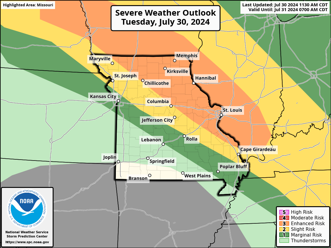
Missouri Severe Weather Outlooks
Day 1 Outlook (Today/Tonight)
Day 2 Outlook (Tomorrow/Tomorrow Night)
Day 3 Outlook
Day 4-8 Severe Weather Outlooks
Statewide Region Severe Weather Outlooks
Day 1 Outlook (Today/Tonight)
Day 2 Outlook (Tomorrow/Tomorrow Night)
Day 3 Outlook